Earth's magnetic North Pole shifts toward Siberia
The magnetic field is relocating due to the movement of molten iron and nickel within the planet’s core.
In a significant development for global navigation, scientists have officially updated the location of Earth's magnetic North Pole, confirming its continued movement away from Canada and toward Siberia. This shift requires recalibrations in navigation systems used by ships, airplanes, and other critical infrastructure worldwide.
The updated position comes from the latest World Magnetic Model (WMM), a collaborative effort between the U.S. National Oceanic and Atmospheric Administration (NOAA) and the British Geological Survey (BGS).
The WMM, revised every five years, provides an accurate map of Earth's magnetic field, which is essential for navigation tools like compasses and GPS systems, the National Centers for Environmental Information said in a release.
More to read:
Google to rename Gulf of Mexico to "Gulf of America" in Maps after government update
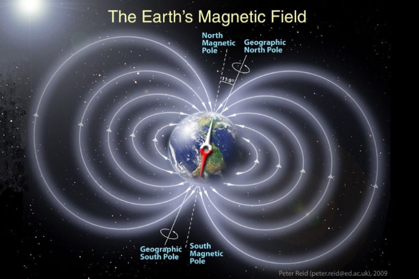
Unlike the fixed geographical North Pole, which marks the Earth's rotational axis, the magnetic North Pole is where the planet's magnetic field points vertically downward. This point is not static; it shifts as the molten iron and nickel in Earth's core move, altering the magnetic field.
"The current behaviour of magnetic north is something that we have never observed before," the BGS’ global geomagnetic field modeller William Brown told ScienceAlert.
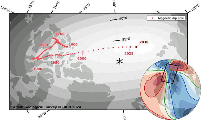
Magnetic north has been moving slowly around Canada since the 1500s, but in the past 20 years, it accelerated toward Siberia, increasing in speed every year until about five years ago, when it suddenly decelerated from 50 to 35 kilometers [31 to 22 miles] per year.
This is the biggest deceleration in speed the scientists have ever recorded, according to Brown.
Researchers attribute this movement to two massive magnetic lobes — one beneath Canada and the other beneath Siberia — which influence the pole's trajectory. These shifts can sometimes be so dramatic that emergency updates to the WMM are required outside the usual five-year cycle.
More to read:
Ukraine demands apologies from FIFA over Crimea map
The newly updated model, which will remain in use for the next five years, includes a higher-resolution map offering more than 10 times the detail of previous versions. For example, the spatial resolution at the equator has improved from 3,300 to about 300 kilometers.
The implications of these updates are significant. According to BGS, using the outdated WMM for navigation could result in substantial deviations. For instance, a straight-line journey from South Africa to the U.K. — approximately 8,500 kilometers (5,282 miles) — could leave travelers 150 kilometers (93 miles) off course if relying on the old model.
As a result, mapping and logistics companies, governments, and official agencies are required to adopt the updates.
More to read:
[video] Scientists officially map out Earth’s 8th continent
Major airlines will upgrade the navigation software across their entire fleets to load in the new model, and militaries in NATO will need to upgrade software in a huge number of complex navigation systems across all kinds of equipment.
Fortunately, for everyday users of smartphones and car navigation systems, updates will occur automatically, prompting no action on their part.
The magnetic North Pole was first discovered by James Clark Ross in northern Canada in 1831. Since then, advancements in ground-based measurements and satellite technology have allowed scientists to track its movement with increasing precision.
***
NewsCafe is an independent outlet. Our sources of income amount to ads and subscriptions. You can support us via PayPal: office[at]rudeana.com or https://paypal.me/newscafeeu, or https://buymeacoffee.com/newscafe - any amount is welcome. You may also want to like or share our story, that would help us too.


Copyright © 2021 All Rights Reserved.