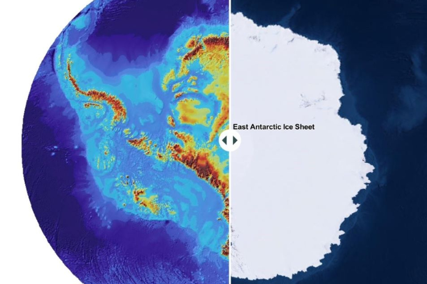
ESA satellite discovers lost continents beneath Antarctica’s ice
Remnants of ancient continents have been uncovered beneath the frozen expanse of Antarctica using data from the European Space Agency's now-retired Gravity field and Ocean Circulation Explorer (GOCE) satellite. Although GOCE ceased operations five years ago, its gravitational field maps have proven invaluable.
A team of geologists from Germany's Kiel University has revealed rocky crusts left behind by long-destroyed landmasses. By combining this data with seismological studies, they created detailed 3D maps of the crust lying beneath Antarctica’s ice.
The research indicates that the crust beneath Antarctica is fragmented in ways that echo the world’s current coastlines. These findings, published in the journal Nature, suggest that Antarctica’s crust was once part of the ancient supercontinent Pangaea.
More to read:
[video] Scientists officially map out Earth’s 8th continent
Specifically, the crust in East Antarctica shows similarities to the geology of Australia and India, pointing to their once-close connection. Meanwhile, the crust in West Antarctica displays a different composition, aligning it with other ancient landmasses. This discrepancy offers a clearer picture of how the continents once fit together before drifting apart over millions of years.
To set the record straight: this discovery has nothing to do with glamorous utopia Atlantis or any mythical undersea kingdom. Instead, it highlights the relentless reshaping of Earth’s crust caused by the movements of tectonic plates over eons.
The research provides valuable clues to the history of our planet, helping scientists piece together the puzzle of Earth’s ancient landscapes.
***
NewsCafe is an independent outlet that cares about big issues. Our sources of income amount to ads and donations from readers. You can support us via PayPal: office[at]rudeana.com or paypal.me/newscafeeu, or https://buymeacoffee.com/newscafe . Any amount is welcome.


![[video] OpenAI claims to achieve milestone artificial intelligence level](/news_img/2024/12/26/news2_mediu.jpg)


